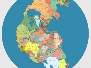

Can you imagine a world where you could drive from Washington, D.C., to Abuja, the capital of Nigeria? Italian artist “Massimo” can. He illustrated what the world would look like if the continents reverted to Pangaea, the ancient supercontinent that broke apart to form the continents we know today. Incorporating today’s political borders, the map makes for some interesting neighbors while distancing countries that are currently located close together. If Pangaea existed today, London would no longer be a short plane ride away from New York; instead, parts of Africa, Canada, and Greenland would lie in the way. Brazil would be just a jump away from the Congo, and Iran would be split in half!
What other interesting differences do you see on this modern-day map of Pangaea?
[via Popular Science]


Interesting. Who knows, maybe Pangaea will reemerge one day! Of course, that level of tectonic shift would take hundreds of millions if not billions of years to occur… so let’s not hold our breath.
Cool ad campaign opportunity for Spain; “Spain, the heart of it all.”
Interesting, I see that a good portion of the US would lose out of having ocean for beaches and resorts.
that’s funny
lol
Rather liked this map…. Would certainly be more convenient!
Wish the map was better able to zoom…. Quite hard to read where some of the new countries would be!
I suppose there would be divisions, but they would differ from today. Construction folks would be busy designing highways to keep everyone connected. For some a trip to the beach would take longer.
I’ve always wanted to live on the equator.